
Choosing a drone camera for mapping is about more than just resolution. For reliable survey results, you need stable flight, consistent image capture, accurate positioning, and a camera system that fits your workflow.
In this roundup, we focus on models that offer practical advantages for mapping use, from dedicated multispectral options to high-end camera drones with strong flight performance and image quality.
Best 10 Drone Camera for Mapping Picks for 2026
NDVI Mapping Specialist
Survey3W OCN NDVI Mapping Camera

- OCN spectral capture for NDVI mapping
- No-distortion 3.37mm f/2.8 lens
- PWM trigger, Wi-Fi, and HDMI support
Best For: NDVI vegetation surveys and drone mapping
Premium Aerial Workhorse
DJI Mavic 4 Pro Fly More Combo

- 100MP Hasselblad camera with 6K60 HDR
- Up to 51 minutes of flight time
- Omnidirectional avoidance with LiDAR
Best For: Professional aerial imaging and long flight missions
Vegetation Index Pick
Survey3W RGN NDVI Mapping Camera
- RGN capture for vegetation analysis
- No-distortion lens for mapping outputs
- PWM trigger, Wi-Fi, and HDMI included
Best For: RGN-based NDVI surveys and ortho-mosaic work
Flagship Camera Drone

- 100MP Hasselblad main camera
- 51-minute flight time and O4+ range
- DJI RC 2 included in the box
Best For: High-end aerial imaging with a controller included
AI Beginner Mapping Drone

- 4K camera with 3-axis gimbal
- AI-assisted flight and return-to-home
- 360° obstacle avoidance with LiDAR
Best For: Beginners needing stable aerial scouting and easy flight help
Pro Mapping Imaging Drone
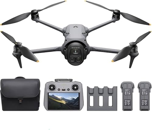
- 100MP Hasselblad camera with 6K/60fps HDR
- 51-minute flight time and 30 km transmission
- Triple-camera system with LiDAR sensing
Best For: Advanced aerial imaging and long-duration professional flights
Professional GPS Mapping Drone

- 4K/30fps camera with adjustable lens
- GPS, optical flow, and return home
- 42-minute flight time with 4-mile range
Best For: GPS-stable aerial capture and outdoor tracking
Premium Travel Mapping Drone
DJI Air 3S Fly More Combo (RC 2)

- 1-inch CMOS primary camera
- 4K/60fps HDR with 14 stops dynamic range
- 45-minute flight time and 20km transmission
Best For: Travelers and creators needing long-range, high-detail aerial capture
Bundle Pick for Long Sessions
DJI Air 3S Fly More Combo w/ 2-Year Warranty

- 1-inch CMOS camera with 4K/60fps HDR
- 45-minute flight time with 20km range
- Includes 2-year warranty and 128GB SD card
Best For: Shoppers wanting a ready-to-fly bundle with extra warranty coverage
Compact Advanced Mapping Drone
DJI Mini 5 Pro Fly More Combo Plus

- 1-inch CMOS sensor with 4K/60fps HDR
- 225° gimbal rotation and true vertical filming
- Up to 52 minutes of flight time
Best For: Creators and beginners who value portability plus strong imaging features
NDVI Mapping Specialist – Survey3W OCN NDVI Mapping Camera
If you need a drone camera for mapping vegetation health, this Survey3W OCN model is built around calibrated OCN imaging for NDVI work. It captures 12MP RAW+JPG stills or 2K video, and the no-distortion 3.37mm f/2.8 lens is designed to support clean maps, ortho-mosaics, and 3D models from drone flights.
Best For: Users who want an NDVI-focused mapping camera with OCN spectral capture and easy drone integration.
Pros:
- Captures OCN imagery with Near Infrared, Orange, and Cyan channels for vegetation analysis
- No-distortion wide-angle lens helps produce cleaner map and mosaic outputs
- PWM trigger support and timer interval mode add flexibility for drone use
- Built-in Wi-Fi and HDMI make review and sharing faster in the field
Cons:
- Only 12MP still capture, which is modest compared with some aerial photo drones
- Not water resistant
- Requires app setup and calibration workflow for NDVI-style results
For mapping projects centered on crop health or vegetation contrast, this camera stays focused on the job rather than general-purpose imaging. Its spectral channels, trigger options, and map-friendly lens make it a practical pick for specialized drone survey work.
Premium Aerial Workhorse – DJI Mavic 4 Pro Fly More Combo
For buyers looking for a drone camera for mapping that also handles high-end aerial imaging, the DJI Mavic 4 Pro brings a 100MP Hasselblad wide camera, 6K60 HDR video, and a triple-camera setup. While it is not a dedicated survey camera, its long flight time, strong range, and obstacle sensing make it a capable platform for broad aerial capture and professional site documentation.
Best For: Professional users who want a high-resolution drone camera platform with extended flight time and advanced tracking.
Pros:
- 100MP main camera with 6K60 HDR for highly detailed capture
- Up to 51 minutes of flight time supports longer missions
- Omnidirectional obstacle avoidance plus LiDAR adds safety in complex environments
- Fly More Combo includes useful extras like backpack, landing pad, and 128GB memory
Cons:
- Built for general professional imaging rather than specialized NDVI mapping
- Advanced feature set may be more than casual users need
- Large, premium package is aimed at expert-level operation
This is a strong all-around aerial imaging drone if your mapping workflow benefits from high-resolution visuals and long flight windows. It is best viewed as a premium capture tool rather than a purpose-built survey sensor.
Vegetation Index Pick – Survey3W RGN NDVI Mapping Camera
This Survey3W RGN model is a purpose-built drone camera for mapping vegetation health, using Red, Green, and Near Infrared capture for NDVI workflows. It records 12MP RAW+JPG images or 2K video, and its no-distortion wide-angle lens is designed to support maps, ortho-mosaics, and 3D models.
Best For: Users who want an RGN spectral mapping camera for vegetation analysis and drone surveying.
Pros:
- RGN spectral layout captures Red, Green, and Near Infrared light for NDVI-style analysis
- No-distortion 3.37mm f/2.8 lens supports cleaner mapping results
- PWM trigger or timer interval shooting adds flexibility for drone missions
- Built-in Wi-Fi and HDMI simplify review and sharing
Cons:
- 12MP still resolution may be limiting for users expecting a standard photo drone
- Not water resistant
- Requires a mapping workflow to turn captures into usable vegetation indices
If your priority is vegetation mapping rather than general aerial photography, this camera is aligned with that job from the start. The RGN filter set and trigger options make it a focused tool for survey-style drone work.
Flagship Camera Drone – DJI Mavic 4 Pro with DJI RC 2
If you want a premium drone camera for mapping-style aerial capture, the DJI Mavic 4 Pro stands out for its 100MP Hasselblad main camera, 6K/60fps HDR video, and dual tele cameras. It is a professional imaging drone with long flight time, long-range transmission, and omnidirectional night sensing, making it a strong choice for high-detail site capture and broad aerial documentation.
Best For: Professionals who want a flagship drone camera with high-resolution imaging, long range, and a controller included.
Pros:
- 100MP 4/3 CMOS Hasselblad camera with 6K/60fps HDR video
- Dual tele cameras add flexible zoom options for detailed aerial shots
- 51-minute max flight time supports extended shoots
- Includes DJI RC 2 and O4+ transmission with up to 18.6-mile range
Cons:
- Not a dedicated NDVI or multispectral mapping camera
- Premium professional features may be unnecessary for basic users
- Best suited to experienced pilots and photographers
This model is best for high-end aerial imaging when you need resolution, range, and flight endurance more than specialized survey sensors. For mapping-related projects, it offers strong visual data capture, but it is primarily a flagship camera drone rather than a dedicated mapping instrument.
AI Beginner Mapping Drone – DCX Volo X EZ 4K
If you want a drone camera for mapping-style aerial overview work and you’re new to flying, the DCX Volo X EZ focuses on stability and automation. Its 4K camera, 3-axis gimbal, and AI-assisted flight features are aimed at smoother capture, while the obstacle avoidance system helps reduce stress during basic route planning and scouting flights.
Best For: Beginners who want a simple 4K drone for stable aerial viewing, property scouting, and easy flight assistance.
Pros:
- 4K camera with 3-axis gimbal and electronic image stabilization for steadier footage
- AI-assisted flight features like Follow Me and Precision Return-to-Home
- 360° obstacle detection with LiDAR sensors for safer flying in tighter areas
- Up to 45 minutes of flight time and a 4-mile range for longer sessions
Cons:
- Designed as a beginner-friendly drone, so it is not positioned as a pro mapping platform
- Requires removing foam padding under the camera before first use
This is a practical choice if you value easy flight control and stable video more than advanced surveying workflows. It offers a strong mix of range, battery life, and safety features for general aerial inspection and mapping-style use.
Pro Mapping Imaging Drone – Mavic 4 Pro Fly More
For buyers comparing a premium drone camera for mapping, the DJI Mavic 4 Pro stands out for image detail, long flight time, and reliable transmission. Its 100MP Hasselblad camera, triple-camera system, and 6K/60fps HDR recording are built for demanding aerial capture where precision and clarity matter.
Best For: Advanced users who need high-end imaging, long endurance, and strong subject tracking for professional aerial work.
Pros:
- 100MP Hasselblad camera with 4/3 CMOS sensor for highly detailed photos
- Triple-camera system with dual telephoto lenses for distant detail capture
- 51-minute flight time and O4+ transmission up to 30 km
- Omnidirectional obstacle sensing with LiDAR and 0.1-lux nightscape vision
Cons:
- Rated for advanced skill levels, so it is less suitable for first-time pilots
- Feature set may be more than casual users need for simple flights
This is the strongest fit here for users who want top-tier imaging and long mission time in a single package. If your mapping or aerial documentation needs lean toward professional-grade capture, this model is built for that job.
Professional GPS Mapping Drone – Contixo F33 4K
The Contixo F33 is a practical drone camera for mapping-style flights when you want GPS stability, a live view remote, and a camera that can handle steady overhead capture. Its 4K/30fps camera, 2-axis gimbal with EIS, and long-range FPV make it a strong option for surveying-looking shots, outdoor tracking, and general aerial documentation.
Best For: Pilots who want a GPS-enabled drone with stable video, long flight time, and easy-to-use tracking features.
Pros:
- 4K UHD camera with 100° wide lens and adjustable angle
- 2-axis gimbal plus EIS for steadier footage
- 42-minute flight time and 4-mile maximum range
- GPS return home, optical flow, and front-side laser obstacle avoidance
Cons:
- 8MP still resolution is modest compared with higher-end imaging drones
- Maximum video capture is 4K/30fps, not higher-frame-rate 4K options
Overall, the F33 is a balanced pick if you want practical stability and mapping-friendly flight aids without moving into premium pricing territory. The included touchscreen remote and SD card also make it easy to get started right away.
Premium Travel Mapping Drone – DJI Air 3S Fly More Combo (RC 2)
If you want a drone camera for mapping-style scouting and location capture, the DJI Air 3S gives you a strong mix of image quality, range, and safety features. Its 1-inch CMOS primary camera, 4K/60fps HDR video, and panorama options make it well suited to documenting large areas with more detail and fewer guesswork passes.
Best For: Travelers, creators, and survey-minded flyers who want a high-end camera drone with long flight time and reliable obstacle sensing.
Pros:
- 1-inch CMOS primary camera for detailed shots, including low-light scenes.
- 4K/60fps HDR video with up to 14 stops of dynamic range.
- 45-minute max flight time and 20km video transmission for wider coverage.
- Forward-facing LiDAR and omnidirectional sensing help with safer flying.
Cons:
- Battery charger is sold separately.
- More of a premium setup than a lightweight beginner pick.
Overall, this is a strong choice if you want a versatile drone camera for mapping broad scenes, scouting terrain, or capturing structured visual coverage with fewer interruptions.
Bundle Pick for Long Sessions – DJI Air 3S Fly More Combo w/ 2-Year Warranty
This DJI Air 3S bundle is a practical drone camera for mapping-oriented work where you want longer time in the air and extra support gear. It keeps the same 1-inch CMOS camera, 4K/60fps HDR capture, panorama modes, and 45-minute flight potential, while adding a 2-year warranty and a 128GB SD card for more storage headroom.
Best For: Buyers who want the Air 3S experience with extra warranty coverage and a ready-to-fly accessory bundle.
Pros:
- 1-inch CMOS camera with 4K/60fps HDR video.
- 45-minute max flight time and 20km transmission.
- Includes a 2-year warranty, 128GB SD card, and three batteries.
- Forward-facing LiDAR and additional sensors support safer flying.
Cons:
- Still a premium, not budget, purchase.
- RC-N3 controller may be less convenient than a built-in screen remote.
If you want a drone camera for mapping and repeated field sessions, this bundle is attractive because it reduces add-on shopping and gives you more support out of the box.
Compact Advanced Mapping Drone – DJI Mini 5 Pro Fly More Combo Plus
The DJI Mini 5 Pro is a compelling drone camera for mapping when portability matters just as much as image quality. It combines a 1-inch CMOS sensor, 4K/60fps HDR video, true vertical filming, and 225° gimbal rotation in a palm-sized foldable body with internal storage, making it easy to carry and quick to deploy.
Best For: Creators and beginners who want a compact drone with high-end camera features and long battery life.
Pros:
- 1-inch CMOS sensor with 4K/60fps HDR video.
- 225° flexible gimbal rotation and true vertical filming.
- Up to 52 minutes of flight with Intelligent Flight Battery Plus.
- Nightscape omnidirectional obstacle sensing and upgraded ActiveTrack 360°.
Cons:
- Best flying time depends on using the included Plus batteries.
- Night flying may require checking local rules and permits.
For buyers who want a smaller drone camera for mapping projects, scouting, or content capture, the Mini 5 Pro stands out for its mix of portability, advanced camera controls, and extended endurance.
How We Picked the Best Drone Camera for Mapping
We prioritized cameras and drone platforms that can support repeatable aerial capture, not just eye-catching specs. That means looking at image quality, stabilization, flight endurance, obstacle sensing, transmission reliability, and features that help produce consistent map inputs.
For a Drone Camera for Mapping, the best choice depends on whether you need true survey and vegetation-analysis capability, or simply a dependable aerial imaging platform for site documentation and visual mapping.
Quick Comparison
Dedicated mapping and multispectral models are the strongest fit when you need vegetation indices, spectral analysis, or repeatable agricultural surveys. High-end consumer drones are better for photogrammetry, inspections, and general aerial mapping where sharp detail and long flight times matter more than spectral data.
Compact drones can be easier to deploy and transport, while larger flagship models usually deliver better cameras, smarter obstacle avoidance, and longer runtimes. The best option is the one that matches your accuracy needs, terrain, and post-processing workflow.
Key Buying Factors for a Drone Camera for Mapping
Camera and Sensor Quality
Look for a sharp sensor with good dynamic range and minimal distortion. For mapping, image consistency often matters more than cinematic features. A fixed, well-calibrated lens and clean edge-to-edge clarity help improve stitching and reduce processing issues.
Flight Stability and Positioning
Stable hovering, strong GPS performance, and dependable return-to-home behavior are essential. If you plan to build orthomosaics or 3D models, smooth flight paths and repeatable positioning improve overlap and reduce gaps in coverage.
Battery Life and Coverage
Longer flight times let you cover more ground per sortie and reduce the number of takeoffs and landings. That can save time on large properties, construction sites, and agricultural fields.
Workflow Features
Screen-equipped controllers, intelligent flight modes, obstacle sensing, and fast data transfer can make field work easier. For a dedicated Drone Camera for Mapping, also consider whether the system supports the capture frequency and metadata quality your software expects.
Who Should Buy Which Drone Camera for Mapping?
If you need multispectral analysis or crop-health insights, choose the dedicated mapping cameras first. If your work is mostly photogrammetry, site documentation, or inspection-style mapping, a premium camera drone with strong stabilization and long flight time is usually the better value.
Beginners and occasional users should favor simpler systems with reliable obstacle avoidance and easy controls. Professional users who process large projects should lean toward the most consistent camera platform and the longest practical flight endurance within budget.
In short, the best Drone Camera for Mapping is the one that balances image consistency, flight reliability, and the specific type of maps or analysis you need to produce.