
Choosing the right drone for construction mapping is about more than camera specs. Accuracy, workflow, and repeatability matter just as much as flight time or image quality.
This roundup focuses on drones for construction mapping that can support site surveys, progress tracking, and dependable aerial data collection for real-world jobs.
Best 10 Drones for Construction Mapping Picks for 2026
RTK Precision Mapping Pick
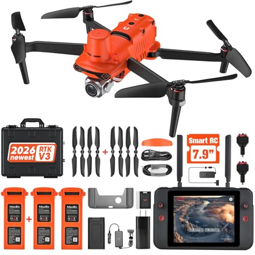
- Centimeter-level RTK positioning
- Supports RTK base station and PPK
- 6K HDR camera for mapping work
Best For: Survey-style construction mapping and photogrammetry
DIY Build and Research Pick

- DIY frame for custom builds
- Pixhawk and GPS included
- Room for sensors, camera, and Raspberry Pi
Best For: Builders and researchers creating a custom mapping platform
Portable Enterprise Mapping Pick

- Compact 866 g enterprise drone
- 1-inch 6K camera with adjustable aperture
- Up to 120 minutes total flight time
Best For: Portable site documentation and inspection work
Workflow Guide Pick
Drone Photogrammetry for Real Projects

- Covers capture, process, and validation
- Includes RTK, PPK, and ground control
- Targets construction and survey workflows
Best For: Operators wanting a practical photogrammetry workflow guide
Precision Mapping-Friendly Camera Drone

- 48MP 8K photos and 4K/30fps video
- 3-axis gimbal for stable aerial footage
- 74-minute total flight time with two batteries
Best For: Large-site scouting and stable visual documentation
Survey Target Ground Control Set

- 24"x24" targets for low to medium altitude mapping
- Center eyelet supports precise placement
- Works with Pix4D, DroneDeploy, and other software
Best For: Reusable ground control for photogrammetry and survey work
Long-Range Site Capture Drone

- 4K HD camera with 3-axis gimbal and EIS
- Up to 84 minutes total flight time
- 360° obstacle avoidance plus payload release
Best For: Extended site coverage with safety-focused flight features
Field-Ready GCP Markers
Bull's-Eye Drone Ground Control Point GCP

- 10-pack of 24" x 24" bull's-eye targets
- Numbered center eyelets for point tracking
- Pix4D and DroneDeploy compatible
Best For: Construction mapping teams needing visible, stable GCP markers
Land Mapping Workflow Guide
Aerial Mapping with Drones for Land Developers

- Covers flight planning and data capture
- Focuses on terrain, volume, and CAD-ready data
- Simple guide for land development workflows
Best For: Readers learning drone mapping workflows for development projects
GCP Field Guide
Ground Control Points for Surveying and Drone Mapping Projects

- Covers GCP placement, RTK, and PPK workflows
- Includes Pix4D and Metashape guidance
- Focuses on checkpoints, RMSE, and reporting
Best For: Survey and construction teams building accurate drone mapping workflows
RTK Precision Mapping Pick – Autel EVO II Pro RTK V3
If you need drones for construction mapping where accuracy matters, the Autel EVO II Pro RTK V3 is built around centimeter-level positioning and mission automation. Its RTK base station and network support, plus PPK and time synchronization, make it a strong fit for repeatable site capture when you want reliable coordinates without depending on ground control points.
Best For: Survey-style construction mapping, photogrammetry workflows, and teams that need real-time centimeter-level positioning.
Pros:
- 1 cm + 1 ppm horizontal and 1.5 cm + 1 ppm vertical RTK positioning accuracy.
- Supports RTK base station, RTK network, and PPK for flexible field workflows.
- Waypoint, Rectangle, Polygon, and Oblique Photography missions help repeat captures.
- 1-inch 6K/30fps HDR camera is suited to mapping and photogrammetry output.
Cons:
- Autel Mapper has specific Windows and NVIDIA graphics requirements.
- Advanced RTK and mapping features may be more than casual users need.
For construction teams that value position accuracy over simplicity, this model stands out as a serious mapping tool. It is especially compelling when your workflow calls for repeatable flight paths, strong GNSS support, and fewer dependencies on GCP-heavy processes.
DIY Build and Research Pick – HAWK’S WORK F450 Drone Kit
For drones for construction mapping projects that need custom hardware or learning-focused experimentation, the HAWK’S WORK F450 Drone Kit gives you a roomy DIY platform to build around. It includes Pixhawk and GPS support, and the frame has space for a flight controller, Raspberry Pi, camera, and sensors, making it practical for secondary development and research work.
Best For: Builders, researchers, and teams developing a custom mapping drone setup from a flexible frame.
Pros:
- 450mm wheelbase and about 1.8 kg max take-off weight offer room for components.
- Includes Pixhawk and GPS for DIY drone development.
- Space for flight control, Raspberry Pi, camera, and sensors.
- Quick start guide helps with assembly and calibration.
Cons:
- Flight controls are not included in the kit.
- Requires assembly and calibration, so it is less turnkey than a ready-to-fly option.
This kit makes sense when you want control over the platform rather than an all-in-one mapping solution. It is better viewed as a development base for custom inspection or mapping builds than as a finished field drone.
Portable Enterprise Mapping Pick – Autel EVO Lite 6K Enterprise
If you want drones for construction mapping with a lighter carry load, the Autel EVO Lite 6K Enterprise focuses on portability without giving up enterprise-oriented imaging tools. Its 1-inch 6K camera, adjustable aperture, and long battery package make it a strong candidate for site documentation, inspection passes, and mapping-adjacent field work where mobility matters.
Best For: Crews that need a compact enterprise drone for site inspection, documentation, and extended field use.
Pros:
- Lightweight, compact design at 866 grams with folded dimensions of 210×123×95 mm.
- 1-inch 6K camera with F2.8–F11 aperture and 16x digital zoom.
- Three batteries provide up to 120 minutes total flight time.
- Three-way obstacle sensing and enterprise app features support industry use.
Cons:
- Transmission tops out at 12 km, which may not match more specialized long-range platforms.
- No RTK specification is listed in the supplied notes.
This is a practical choice when portability, image quality, and long working time matter more than top-end survey positioning. For teams moving between job sites, its compact form and enterprise software support are the main advantages.
Workflow Guide Pick – Drone Photogrammetry for Real Projects
DRONE PHOTOGRAMMETRY FOR REAL PROJECTS: MAPPING, SURVEYING, INSPECTION, AND 3D DATA WORKFLOWS
Check Price On AmazonWhen you are comparing drones for construction mapping, the aircraft is only part of the workflow, and this guide focuses on the rest. Drone Photogrammetry for Real Projects walks through capture, processing, and validation so you can plan flights, manage ground control or RTK/PPK, and produce outputs like orthomosaics, point clouds, and volume reports with fewer mistakes.
Best For: Teams and operators who want a practical photogrammetry workflow guide for real construction and survey projects.
Pros:
- Explains the full capture → process → validate workflow.
- Covers flight planning, camera setup, ground control, RTK, and PPK.
- Includes real project types like construction tracking and stockpile measurement.
- Focuses on checking accuracy and avoiding reflights.
Cons:
- It is a book, not a drone or hardware bundle.
- Best used as a workflow reference alongside your equipment.
If your goal is more consistent mapping results, this guide is a useful companion to any construction drone setup. It is especially helpful for operators who want a clearer process from field capture to final deliverable.
Precision Mapping-Friendly Camera Drone – Ruko F11PRO 2 Plus
If you want a camera drone that can support drones for construction mapping at a broad-property level, the Ruko F11PRO 2 Plus offers the flight time, range, and image quality to help with scouting and visual documentation. Its 48MP sensor, 3-axis gimbal, and long transmission distance make it more useful for site overviews than a basic hobby drone.
Best For: Users who need long-range aerial scouting, stable overhead footage, and extended flight sessions for large-site visual checks.
Pros:
- 48MP 8K stills and 4K/30fps video for detailed site imagery
- 3-axis mechanical gimbal helps keep footage steady
- 74 minutes total flight time from two included batteries
- 20,000 ft transmission supports wide-area flying and scouting
Cons:
- Not a dedicated surveying or photogrammetry drone
- Construction mapping workflows will still depend on external software and process
- Best results will come from calm conditions and careful flight planning
Overall, this is a strong fit if your priority is clear, stable aerial capture over large construction areas rather than specialized mapping hardware. It gives you the endurance and image stability to gather useful visual reference material efficiently.
Survey Target Ground Control Set – Sky High Bull's-Eye GCP 24×24
For drones for construction mapping, ground control points are essential when you need more accurate reference data during photogrammetry. This Sky High Bull’s-Eye GCP set is built for low to medium altitude mapping, with a 24″x24″ format that is easy to spot and a center eyelet that helps with precise placement.
Best For: Field teams that need reusable, highly visible ground targets for photogrammetry and survey workflows.
Pros:
- 24″x24″ targets designed for mapping up to 400 feet
- Center eyelet makes target centering easier with a survey rod
- Weatherproof mesh material is lightweight and durable
- Compatible with major photogrammetry software like Pix4D and DroneDeploy
Cons:
- Targets are an accessory, not a drone
- Best suited to workflows that already use GCP-based processing
- Large 24″x24″ size may be more than needed for small-area jobs
This is a practical add-on for anyone building a more accurate mapping workflow on construction sites. The visibility, anchoring points, and software compatibility make it a straightforward tool for repeatable ground reference work.
Long-Range Site Capture Drone – Bingchat AE Pro Serial
If your version of drones for construction mapping needs long range, long flight time, and extra safety features, this Bingchat AE Pro Serial model is positioned as a capable site-capture option. It combines a 4K HD camera, 3-axis gimbal, obstacle avoidance, and payload release, which can help when you need to document larger work areas or handle more complex flying conditions.
Best For: Users who want a long-range drone for broad site coverage, extended missions, and more safety-focused flight features.
Pros:
- 4K HD camera with 3-axis gimbal and EIS for steadier footage
- Up to 84 minutes of total flight time with two batteries
- Claims up to 5 miles of range and 360° laser obstacle avoidance
- Payload release, waypoint flight, follow me, and auto return-home features
Cons:
- Range and flight time depend on conditions and signal environment
- Payload release is not a substitute for true mapping hardware
- Some advanced features may be more than a basic site user needs
As a site documentation drone, this model focuses more on endurance, safety, and flexibility than on specialized surveying tools. That makes it useful for broad overhead capture, but mapping workflows will still rely on your own processing setup and flight discipline.
Field-Ready GCP Markers – Bull's-Eye Drone Ground Control Point GCP
For drones for construction mapping, reliable ground control points are essential, and this 10-pack of 24″ x 24″ black-and-white bull’s-eye targets is built for clear field identification. The numbered center eyelets and four corner eyelets make it easier to track coordinates, secure each marker, and keep your mapping workflow organized during survey and site capture jobs.
Best For: Construction teams, mapping operators, and survey workflows that need visible, easy-to-place GCP targets compatible with Pix4D and DroneDeploy.
Pros:
- Black-and-white targets are designed for strong visibility in bright or challenging lighting.
- Numbered center eyelets help with fast point identification and coordinate tracking.
- Four corner eyelets allow secure ground placement for stable data capture.
- Compatible with Pix4D and DroneDeploy workflows.
Cons:
- Sold as markers only, so it is not a full mapping kit.
- Best suited to projects that can use 24″ x 24″ targets.
If your priority is consistent, easy-to-see ground references in the field, these GCP targets fit the job well. They focus on practical placement and visibility rather than extras, which makes them a straightforward choice for drone mapping and surveying work.
Land Mapping Workflow Guide – Aerial Mapping with Drones for Land Developers
If you’re researching drones for construction mapping, this book is aimed at the planning side of the workflow: flight planning, data capture, and turning aerial data into high-resolution maps. It focuses on terrain scanning, volume analysis, and CAD-ready survey data in simple language, making it a practical starting point for readers who want to understand how drone mapping supports development projects.
Best For: Beginners and professionals who want a clear overview of drone-based mapping workflows for land development, construction, and related site planning work.
Pros:
- Covers terrain scanning, volume analysis, and CAD-ready outputs.
- Walks through flight planning, data capture, and map processing.
- Written in simple language for beginners and professionals.
- Highlights how drone mapping can reduce time and cost versus traditional surveying.
Cons:
- It is a guidebook, not a hardware product.
- Publication date is listed in the future, so availability may vary.
This is a useful pick if you want the process behind site mapping rather than equipment specs. It is especially relevant for readers who need to understand how drone mapping outputs fit into real development and construction decisions.
GCP Field Guide – Ground Control Points for Surveying and Drone Mapping Projects
For drones for construction mapping, the accuracy of the final deliverable often comes down to how well ground control is planned and measured. This field guide explains GCP placement, RTK and PPK workflows, GNSS practices, coordinate systems, checkpoints, RMSE, and integration with Pix4D and Agisoft Metashape in practical language for real project use.
Best For: Survey technicians, drone operators, GIS users, engineers, and construction professionals who need a practical GCP workflow manual.
Pros:
- Explains GCP placement and target design in clear, practical terms.
- Covers RTK, PPK, GNSS field practices, and coordinate system basics.
- Includes Pix4D and Agisoft Metashape workflow guidance.
- Addresses checkpoints, RMSE, reporting, and troubleshooting.
Cons:
- It is a book, so it will not provide field hardware or targets.
- More workflow-focused than introductory drone flying content.
This guide is a strong fit when accuracy matters more than aesthetics. It is geared toward readers who need to build better-controlled mapping projects and understand how field decisions affect the final survey output.
How We Picked These Drones for Construction Mapping
We focused on models and supporting tools that fit construction workflows: precise positioning, stable imaging, practical flight endurance, and compatibility with mapping or photogrammetry tasks. We also considered whether a drone is better suited to survey-grade capture, project documentation, or training and field setup.
Quick Comparison
For fast decision-making, think in three buckets: RTK-enabled drones for the highest positional accuracy, enterprise-style drones for flexible jobsite imaging, and mapping accessories such as ground control points and guides for teams building a repeatable workflow. Some products here are not drones themselves, but they support a complete mapping system.
Key Buying Factors for Drones for Construction Mapping
Positioning and Accuracy
If your team needs measurement-ready outputs, look for RTK, GNSS support, or workflows that integrate ground control points. These features help reduce drift and improve consistency across site captures.
Camera and Image Quality
A high-resolution sensor matters, but so does lens quality, dynamic range, and stabilization. Construction sites often have mixed lighting, reflective surfaces, and tall structures, so clean imagery is essential for usable orthomosaics and 3D models.
Flight Time and Coverage
Longer endurance reduces the number of takeoffs needed and helps teams cover larger sites efficiently. For larger developments, battery life can be a real productivity factor.
Workflow Compatibility
Choose equipment that matches your software and field process, whether that means photogrammetry, CAD-ready outputs, terrain scans, or progress documentation. The best Drones for Construction Mapping are the ones your team can use consistently from launch to deliverable.
Field Accessories and Control
Accessories like GCP targets, tablets, base stations, and survey guides can matter as much as the drone itself. They help standardize collection and improve the quality of final mapping results.
Who Should Buy Which Drones for Construction Mapping?
Contractors and survey-focused teams should lean toward RTK or enterprise mapping setups. Developers and site managers who mainly need reliable progress imagery may prioritize endurance and image quality. Teams new to drone mapping should also consider GCP tools and practical field guides to shorten the learning curve.
If you are building a complete stack for Drones for Construction Mapping, the smartest purchase is often not just the aircraft, but the full workflow around it: positioning, capture, and ground verification.