
Choosing the right drone for topographic mapping comes down to more than camera specs. Accuracy, stability, georeferencing, and workflow compatibility all shape the quality of your survey results.
This roundup highlights 10 options with a buyer-first focus, whether you need a compact aerial mapper, an RTK-ready platform, or an enterprise drone built for demanding field work.
Best 10 Drones for Topographic Mapping Picks for 2026
Compact Aerial Mapping Drone
Potensic Atom 2 Fly More Combo
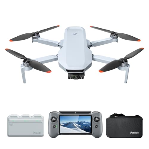
- 48MP camera with 4K/30fps HDR video
- 96-minute total flight time with 3 batteries
- 10KM transmission and GNSS-assisted flight
Best For: portable visual mapping and entry-level topographic imagery
Survey-Grade GNSS Mapping Kit
SMA60AR Rover & SMA20 Pro Base

- RTK, PPK, and PPP support for survey workflows
- Dual cameras for visual measurement and AR stakeout
- IP68 rugged build with 60° tilt compensation
Best For: precision ground control for drone topographic mapping
Enterprise Mapping Drone

- 1-inch CMOS 6K camera with adjustable aperture
- Up to 120 minutes total flight time
- 12KM transmission and 3-way obstacle sensing
Best For: enterprise aerial capture and mapping-focused fieldwork
Thermal Enterprise Drone
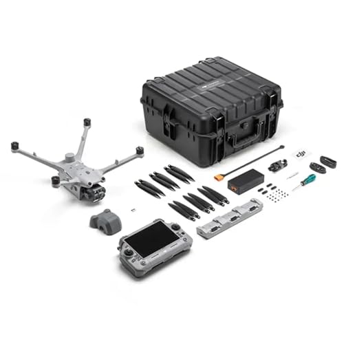
- Triple-lens visual suite with thermal and NIR sensors
- Laser Range Finder for precise target distance
- IP55 rating with anti-ice propellers for harsh weather
Best For: enterprise mapping, inspection, and thermal field operations
Survey-Grade RTK Mapping Drone
Autel EVO II Pro RTK V3 for Mapping/Photogrammetry
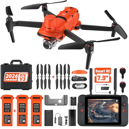
- Centimeter-level RTK positioning
- Supports RTK base station and PPK
- Waypoint and oblique mission modes
Best For: Mapping, photogrammetry, and repeatable survey missions
High-End Imaging Drone

- 1-inch CMOS camera with 4K/60fps HDR
- Up to 45-minute flight time
- Omnidirectional sensing with LiDAR
Best For: Scouting, aerial imaging, and general-purpose flying
RTK Survey Drone
Autel EVO II Pro RTK V3 for Mapping

- Centimeter-level RTK positioning
- PPK support with recorded flight data
- 6K 1-inch camera and mission modes
Best For: Surveying, construction, and precise mapping work
Enterprise Mapping Pick
Autel EVO Lite 6K Enterprise with 1-inch CMOS

- 6K camera with 1-inch CMOS sensor
- 40-minute flight time for longer missions
- 12KM transmission with obstacle sensing
Best For: Survey teams and solo operators needing a compact enterprise drone for aerial documentation
High-Resolution Imaging Pick
DJI Mavic 4 Pro Fly More Combo
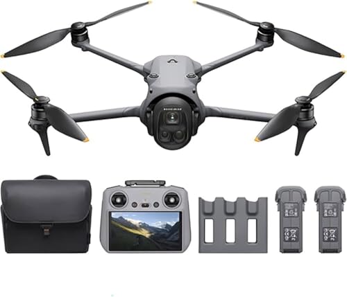
- 100MP Hasselblad camera for detailed stills
- 51-minute flight time for longer missions
- O4+ transmission up to 30 km
Best For: Teams that need premium aerial imaging and long-range flight for site capture
Rugged Long-Range Pick

- 1-inch CMOS sensor with 6K HDR video
- 40-minute flight time and 15KM transmission
- 360-degree obstacle avoidance for complex terrain
Best For: Users who need a rugged drone for detailed aerial capture and longer missions
Compact Aerial Mapping Drone – Potensic Atom 2 Fly More Combo
If you’re comparing drones for topographic mapping, the Potensic Atom 2 Fly More Combo stands out as a lightweight option with strong imaging specs and stable flight control. Its 4K video, 8K photo output, 3-axis gimbal, and GNSS positioning make it a practical choice for capturing detailed aerial visuals and repeatable flight paths.
Best For: hobbyists and light professional users who want a portable mapping-capable drone with strong image quality.
Pros:
- 1/2″ Sony CMOS sensor with 48MP photos and 4K/30fps HDR video
- 10KM transmission and PixSync 2.0 for stable control
- 96-minute flight time with three batteries and fast charging hub
- Under 249g design for easy transport and simpler compliance
Cons:
- Not a dedicated survey drone with RTK or PPK features
- Best suited to visual mapping workflows rather than precision land surveying
- Some advanced modes are more cinematic than measurement-focused
For buyers who need a compact platform for topographic mapping imagery rather than full survey-grade data capture, this is a flexible and travel-friendly pick. It combines long runtime, strong camera hardware, and beginner-friendly flight tools in one small package.
Survey-Grade GNSS Mapping Kit – SMA60AR Rover & SMA20 Pro Base
For drones for topographic mapping, accurate ground control is just as important as the aircraft, and this SMA60AR + SMA20 Pro Base kit is built for that job. It offers RTK, PPK, and PPP support, dual-camera visual measurement, AR stakeout, and rugged field durability for survey workflows in demanding conditions.
Best For: survey crews and GIS teams that need high-precision GNSS support for drone mapping projects.
Pros:
- RTK, PPK, and PPP workflow support for flexible survey use
- Dual cameras enable visual measurement and AR stakeout
- 60° tilt compensation and 1408-channel multi-constellation support
- IP68 protection, 2-meter drop resistance, and wide temperature range
Cons:
- It is a GNSS rover/base kit, not the drone itself
- Requires a surveying workflow to make full use of its capabilities
- More specialized than a general-purpose mapping accessory
This is the strongest choice in the group for mapping accuracy on the ground side of a topographic workflow. If your goal is reliable control, stakeout guidance, and precision positioning, it adds serious value to drone-based mapping operations.
Enterprise Mapping Drone – Autel EVO Lite 6K Enterprise
If you want drones for topographic mapping with more enterprise-focused imaging and flight tools, the Autel EVO Lite 6K Enterprise Plus Combo is a strong candidate. Its 1-inch CMOS 6K camera, adjustable aperture, long battery life, and mission-oriented app make it well suited to detailed aerial capture and inspection-style mapping work.
Best For: enterprise users who want a compact drone with strong image quality and longer mission time.
Pros:
- 1-inch CMOS 6K camera with F2.8-F11 aperture and 16x digital zoom
- Three batteries provide up to 120 minutes total flight time
- 12KM transmission with 3-way obstacle sensing for safer flights
- Enterprise app adds AI target recognition and mission tools
Cons:
- Not advertised with RTK or PPK survey accuracy features
- Designed more for enterprise capture than dedicated photogrammetry hardware
- Some advanced functions depend on the enterprise app workflow
For users who need a capable visual platform for topographic mapping and related fieldwork, this model offers a good mix of image quality, endurance, and safety features. It fits best where mission flexibility matters more than survey-grade positioning hardware.
Thermal Enterprise Drone – DJI Matrice 4TD
Among drones for topographic mapping, the DJI Matrice 4TD is built for advanced field operations where visual detail and environmental awareness matter. With wide, tele, thermal, and NIR tools plus a laser range finder, it supports demanding surveying and inspection workflows that go beyond standard aerial imaging.
Best For: enterprise teams that need a rugged multi-sensor drone for mapping, inspection, and remote operations.
Pros:
- Triple-lens visual system plus thermal sensor and NIR light
- Laser Range Finder helps pinpoint target location and distance
- IP55 weatherproofing and anti-ice propellers for harsh conditions
- RC Plus 2 Enterprise included for immediate deployment
Cons:
- Heavy 10-pound platform is less portable than compact drones
- Aimed at enterprise workflows rather than casual mapping use
- Batteries are not included in the supplied details
This is the most capable pick here for serious professional operations that need more than a basic aerial camera. If your mapping work also involves inspection, thermal analysis, or all-weather deployment, it offers a highly specialized toolkit.
Survey-Grade RTK Mapping Drone – Autel EVO II Pro RTK V3 for Mapping/Photogrammetry
If you need drones for topographic mapping that prioritize positioning accuracy and repeatable mission planning, the Autel EVO II Pro RTK V3 is built for that workflow. Its RTK module supports real-time centimeter-level positioning, plus PPK and RTK base station/network options, so it fits survey-style aerial capture where accurate coordinates matter.
Best For: Teams doing mapping, photogrammetry, urban planning, or repeatable data-collection missions that need centimeter-level positioning.
Pros:
- 1 cm + 1 ppm horizontal and 1.5 cm + 1 ppm vertical positioning accuracy
- Supports RTK base station, RTK network, and PPK workflows
- Waypoint, rectangle, polygon, and oblique mission modes for planned routes
- Includes 1-inch 6K/30fps HDR camera and 38-minute flight time
Cons:
- Best suited to mapping workflows rather than casual flying
- Requires compatible computer specs for Autel Mapper use
For buyers focused on data consistency, this model stands out for its survey-oriented positioning tools and autonomous mission execution. It is a strong fit when your priority is producing usable mapping outputs and repeatable aerial datasets.
High-End Imaging Drone – DJI Air 3S Fly More Combo
The DJI Air 3S is more of an imaging and scouting drone than a dedicated survey platform, but it can still appeal to buyers comparing drones for topographic mapping who also want strong visual detail. Its 1-inch CMOS wide-angle camera, medium tele camera, and 48MP stills give you flexible capture options for location scouting and general aerial documentation.
Best For: Users who want a capable camera drone for scouting, site overview shots, and general aerial imaging alongside light mapping-related work.
Pros:
- 1-inch CMOS primary camera with 4K/60fps HDR video
- Wide-angle and medium tele cameras for varied framing
- Up to 45-minute max flight time with three batteries included
- Omnidirectional sensing plus forward-facing LiDAR for safer flying
Cons:
- No RTK or PPK positioning features listed
- Not purpose-built for survey-grade topographic workflows
If your priority is image quality and flight endurance rather than centimeter-level mapping accuracy, the Air 3S makes sense. It is better viewed as a versatile aerial camera platform than a specialized topographic mapping tool.
RTK Survey Drone – Autel EVO II Pro RTK V3 for Mapping
For buyers comparing drones for topographic mapping, the Autel EVO II Pro RTK V3 is clearly aimed at survey and mapping work. It combines centimeter-level RTK positioning, PPK support, and a 1-inch 6K/30fps HDR camera, giving it the core tools needed for accurate aerial data capture and detailed map generation.
Best For: Surveying, construction, agriculture, and mapping projects that need precise location tracking and reliable mission planning.
Pros:
- 1 cm + 1 ppm horizontal and 1.5 cm + 1 ppm vertical accuracy
- Supports PPK and records satellite observation data and exposure parameters
- Waypoint, rectangle, polygon, and oblique mission modes
- 7.9-inch Smart Controller V3 with 2000-nit brightness
Cons:
- Higher-end feature set is more than casual users need
- Best results depend on using the right mapping workflow and software
This version is the most directly aligned with surveying-style jobs in the group. If your top priority is precise aerial positioning and structured mission capture, it is the most fitting choice here.
Enterprise Mapping Pick – Autel EVO Lite 6K Enterprise with 1-inch CMOS
If you’re comparing drones for topographic mapping, the Autel EVO Lite 6K Enterprise stands out as a compact, single-pilot platform with a 6K camera, 1-inch CMOS sensor, and adjustable F2.8 to F11 aperture for detailed aerial capture. Its 40-minute flight time, obstacle sensing, and 12KM transmission make it a practical choice when you need efficient coverage and stable control in the field.
Best For: Survey teams and public-safety users who want a lightweight enterprise drone with strong imaging and easy solo operation.
Pros:
- 6K camera with 1-inch CMOS sensor for high-detail documentation
- 40-minute flight time supports longer mapping sessions
- 12KM transmission and obstacle sensing help with reliable field operation
- Enterprise flight software includes offline maps and split-screen display
Cons:
- Not positioned as a dedicated survey-grade mapping payload
- 16x digital zoom is useful for inspection, but not a substitute for specialized photogrammetry tools
- Heavier than ultra-compact consumer drones at 866g
Overall, this is a versatile enterprise drone for teams that need strong image quality, dependable range, and straightforward deployment rather than a highly specialized mapping system.
High-Resolution Imaging Pick – DJI Mavic 4 Pro Fly More Combo
For buyers looking at drones for topographic mapping, the DJI Mavic 4 Pro offers the strongest imaging package in this group, led by a 100MP Hasselblad camera, 6K/60fps HDR video, and a triple-camera system. Its 51-minute flight time and O4+ transmission up to 30 km make it well suited to long, careful aerial runs where image quality and range matter.
Best For: Crews that prioritize high-resolution aerial imaging and extended flight time for detailed site capture.
Pros:
- 100MP Hasselblad camera for highly detailed stills
- 6K/60fps HDR video and triple-camera system for flexible capture
- 51-minute flight time supports extended missions
- O4+ transmission reaches up to 30 km
Cons:
- Advanced platform may be more than casual users need
- Topographic mapping still depends on your workflow and processing software
- Higher-end feature set may increase overall kit complexity
This is the best fit if your priority is maximum image detail and long endurance, especially when mapping work benefits from a camera-first drone with strong transmission performance.
Rugged Long-Range Pick – Autel EVO II Pro V3 6K Bundle
The Autel EVO II Pro V3 is a strong option for drones for topographic mapping when you want a rugged build, 6K HDR video, and a 1-inch CMOS sensor with adjustable F2.8-F11 aperture. With 40 minutes of flight time, 15KM transmission, and 360-degree obstacle avoidance, it is built for dependable aerial work in more demanding terrain.
Best For: Mapping-focused users who want a rugged drone with long flight time and dependable image quality.
Pros:
- 1-inch CMOS sensor with 6K HDR video
- 40-minute flight time and 15KM transmission
- 360-degree obstacle avoidance for safer flights in complex terrain
- Smart Controller SE includes a 6.4-inch OLED display
Cons:
- Not marketed as a dedicated survey mapping system
- Bundle adds controller and accessories, which may be more than some buyers need
- Advanced features may be unnecessary for simple photo capture
As a mapping-oriented all-rounder, this model balances image quality, endurance, and control features well for users who need a capable drone that can handle rougher operating conditions.
How We Picked These Drones for Topographic Mapping
We prioritized platforms that support mapping-oriented capture, dependable flight performance, and survey-friendly positioning features. That includes RTK/PPK support where available, strong image quality, stable gimbals, solid transmission range, and battery life that can handle larger sites efficiently.
We also considered how practical each drone is in the field: portability, weather resistance, payload or sensor flexibility, and the ease of integrating the drone into a photogrammetry workflow.
Quick Comparison
The list spans consumer drones with high-resolution cameras, prosumer models that balance portability and image quality, and enterprise systems designed for precision work. If your priority is affordable mapping over smaller areas, a lighter camera drone may be enough. If you need survey-grade outputs, look closely at RTK, PPK, and base-station compatibility.
Key Buying Factors for Drones for Topographic Mapping
Positioning and Georeferencing
For accurate maps and elevation models, the most important feature is reliable positioning. RTK or PPK support can reduce the need for excessive ground control points and improve consistency across flight lines.
Camera and Image Quality
Look for a sharp sensor, low distortion, and enough resolution to produce clear overlap between frames. A 1-inch sensor or larger is often a strong starting point, especially for detailed terrain work and clean orthomosaic output.
Flight Time and Coverage
Longer battery life means fewer takeoffs, fewer interruptions, and better efficiency on larger sites. For mapping, total coverage per battery matters just as much as raw flight time.
Stability, Transmission, and Workflow
Stable hovering, reliable obstacle sensing, and strong signal transmission all help maintain consistent image overlap and safer missions. Make sure the drone fits your planning software and export workflow so field data moves smoothly into your processing pipeline.
Who Should Buy Which Drones for Topographic Mapping?
If you are a surveyor, engineering team, or contractor working on high-accuracy deliverables, an enterprise RTK or PPK drone is the safer choice. If you are a land manager, inspector, or small firm mapping moderate-sized areas, a premium prosumer model may offer the best balance of cost and capability.
For buyers who need a flexible general-purpose drone that can still support mapping tasks, prioritize image quality, flight stability, and flight time over extra consumer features. The best Drones for Topographic Mapping are the ones that match your project scale, accuracy target, and post-processing workflow.